Länsirastit, Olars

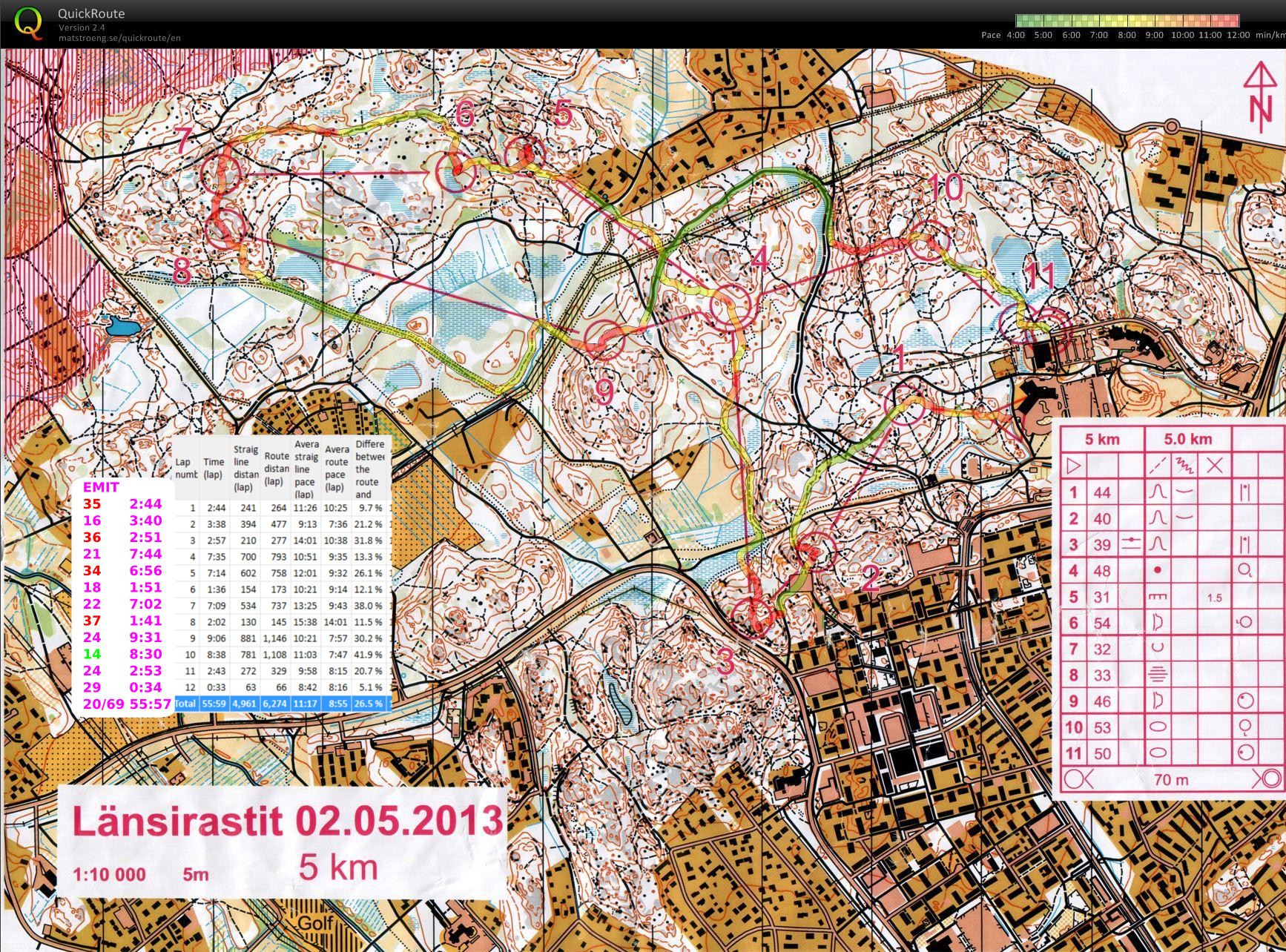
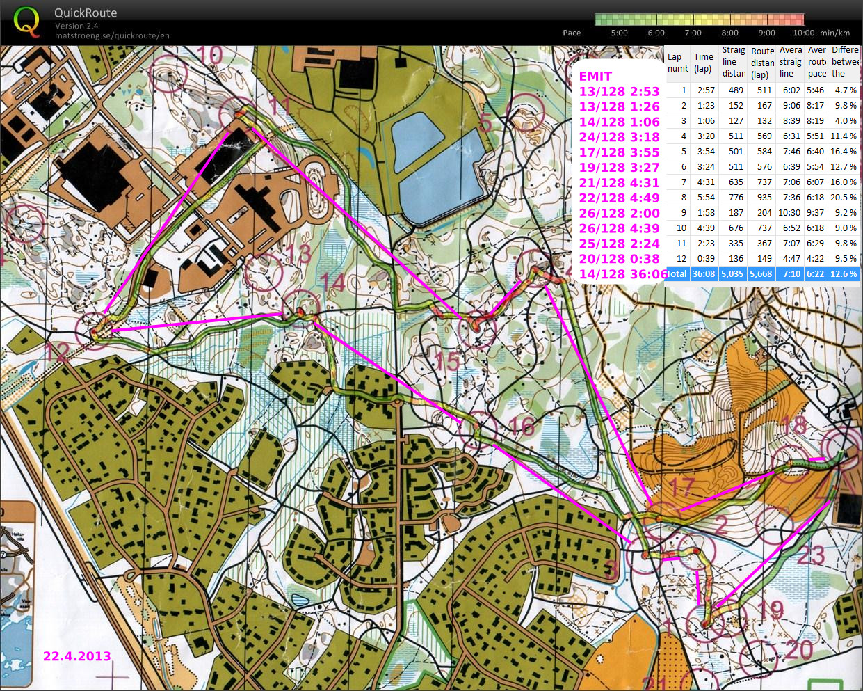
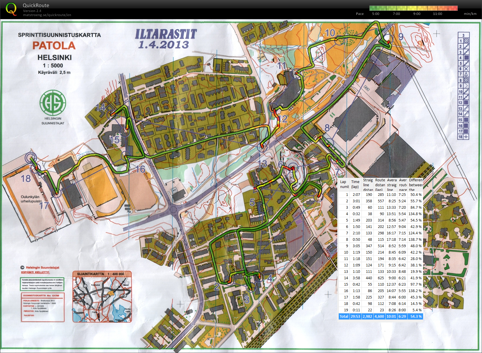
2.5.2013 Olars. Again quite good! Maybe slightly harder course.
#1 maybe a bit too careful at the start
#3 very slow close to the control - went for the wrong feature inside the control-circle
#7 did not have very good control/feel for the distance along the #6-#7 path. should have kept up speed better along the path.
#10 amazingly, the huge detour right around the hill resulted in the best leg on this course! Fast running on the road/path, then very carefully into the control which looked hard to find on the map.

2013_05_02_olars

Iltarastit, Luk

#15-#16 a long pause to read the map on top of the first hill
#16-#17 a small correction to the south just before the control
#18 had a reasonable plan and executed it OK.
#19 again a long pause to read the map
#20 found the swamp instead of the lake 🙁  didn't have a good plan when leaving #19
#21 again poor planning running up/down hills instead of around them.

2013_04_29_luk

Itärastit, Degerö

2013_04_20_degero_qr_splits

A fairly easy course with lots of running along roads and paths.
Right at the beginning on #2 I searched for it on the wrong hill - on the wrong side of the road/path ?!?
#3-#4-#5-#6-#7 nothing to report. Running speed is enough for top-10 placings 🙂
#8 the GPS-path looks ok but speed was slow.
#9 right after #8 the compass seemed to just rotate around and I wasn't confident enough to run by the map alone. Very slow and shaky going to #9.
#10-#11-#12 more fitness required to keep up speed in the forest and uphills
#13 again an easier control and better speed
#14 lost concentration and headed in the wrong direction. Lots of open areas with freshly cut trees (compare to 2012 map)- hard to tell how well the map corresponded to reality here.

Iltarastit, Tali

2013_04_08_tali_qr_splits

Still lots of snow on the ground, and a temperature just barely above freezing this evening.

The first red (slow) bit between #19 and #20 could not be avoided - just too much snow for running. A bigger mistake on the #11-#12 leg where clearly the better choice after the bridge would have been to run up the hill. Instead I continued north along the stream looking for the small and steep trail up to the control - which was of course completely covered in snow and invisible. Having not learnt much from this I then sort of repeated the same mistake on #25-#24 where my route is direct, but very slow because of snow up to knee-level or above. A small U-turn on #23-#15, but it probably did not cost much in terms of time lost.

My timing-receipt from the EMIT-system shows strange split-times. We'll see if those are corrected in the final results.

Sprint orienteering, Ågeli

2013_04_01_ogeli_qr_splits

Orienteering again! All of the snow isn't really gone yet, but the orienteering season kicks in anyway.

This was a 3km easy sprint course where the opportunity for making large errors was quite small. In sprint-O keeping out of the prohibited areas (e.g. back-yards, in green on the map) of the map is a challenge - there are lots of DQs for this in competitions.

I'm not sure how bad going off the map is considered. At the top of the map between #9 and #10 there was an open path where I, and everyone else, ran, but according to the GPS-trace it might be just outside the printed map.

Espoorastit

This is the last orienteering event for this year.

On #5 I somehow started looking for the control too early on the wrong hill. Probably lost 10 min here. Then from #7 I went back to a road and tried to find #8 from there when in hindsight it would have been much better to head for the fence around the radio-mast and use that to find #8. Probably another 4 min or so lost. Between #9-#10 my route is too safe and a more direct route through the wet or frozen field would have been faster.