Iltarastit, Tali

2013_04_08_tali_qr_splits

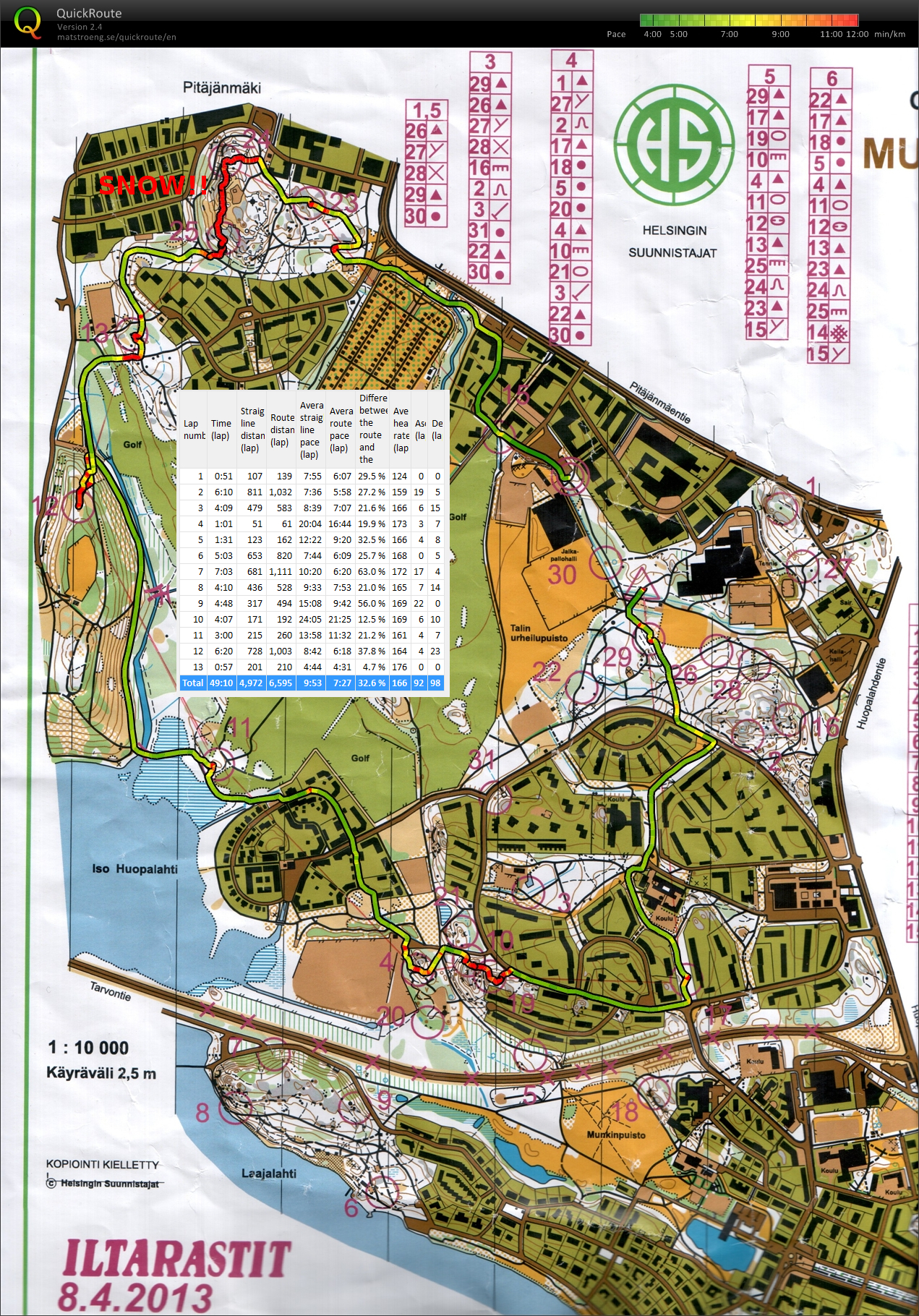
Still lots of snow on the ground, and a temperature just barely above freezing this evening.

The first red (slow) bit between #19 and #20 could not be avoided - just too much snow for running. A bigger mistake on the #11-#12 leg where clearly the better choice after the bridge would have been to run up the hill. Instead I continued north along the stream looking for the small and steep trail up to the control - which was of course completely covered in snow and invisible. Having not learnt much from this I then sort of repeated the same mistake on #25-#24 where my route is direct, but very slow because of snow up to knee-level or above. A small U-turn on #23-#15, but it probably did not cost much in terms of time lost.

My timing-receipt from the EMIT-system shows strange split-times. We'll see if those are corrected in the final results.

Sprint orienteering, Ågeli

2013_04_01_ogeli_qr_splits

Orienteering again! All of the snow isn't really gone yet, but the orienteering season kicks in anyway.

This was a 3km easy sprint course where the opportunity for making large errors was quite small. In sprint-O keeping out of the prohibited areas (e.g. back-yards, in green on the map) of the map is a challenge - there are lots of DQs for this in competitions.

I'm not sure how bad going off the map is considered. At the top of the map between #9 and #10 there was an open path where I, and everyone else, ran, but according to the GPS-trace it might be just outside the printed map.

Iltarastit, Stensböle

They have been running the "evening" orienteering events on Sunday midday for a while now, since it is quite dark after 17-18 or so. This is the last event for Iltarastit, but there are a few other clubs organizing these for a couple of weeks still this season.

Nothing too dramatic on #1, #2, and #3. Then a lot of deep "canyons" and other steep places around #4 which caused some confusion - probably cost me about 5 minutes here. No problems at #5 but a bit of searching for #6 (not too much lost here, max 1 minute). Then I chose to run not straight, but along paths and roads to #7 - we shall see if that paid off when all the results are up on the web. Again a longer route along a path to #8. From #10 it would probably have been slightly faster to run in-between the houses to the road more directly. Nothing special at #11 and #12. Then #13 was drawn close to a fence, but I didn't really know on which side of the fence the control was - luckily there were others running to/from the control so I just followed them.

This took me about 57 minutes. If I could have avoided the big mistake at #4 and some smaller mistakes the time approaches 50minutes, which is OKish for amateur/fitness orienteering on a 5km course (for me anyway!).

Aluerastit, Kumpula

First orienteering event of the year. 5 km course.

Lost in central park

Did a 7km "iltarasti" orienteering course starting from Laakso. 16 controls in total, one and two were easy, then we stumbled on 19 when going for 3, then more or less ok on 4-8, a big miss on nr 9 (just at the top of the map) which features three almost identical 3-road intersections and we mistook the third one for the second one... then again mostly OKish towards the end, with maybe a bit too much walking/searching on 15. The gps shows 9.8km in 1h 45min, so not exactly fast going...